

ITINERARY
Satopanth Lake Trek
A glacial lake with a unique triangular shape. Its crystal-clear waters and mystical aura make it a beautiful and must visit destination.
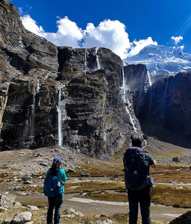
Satopanth Lake Trek
Price
₹21990/person
Satopanth Lake Trek Overview
Along the trail, you will discover Sahastradhara, Vasudhara falls, and lush meadows like Lakshmi Van, each offering you a new experience. This trek offers you spectacular views of iconic Himalayan peaks like Chaukhamba, Avalanche, Neelkanth and Balakun that provide incredible photography opportunities.
The Satopanth Lake trek is fondly known as the “doorway to heaven” and the beauty of this place actually justifies it. Starting from the sacred town of Badrinath and passing through Mana, India’s first village, the trek is a cultural immersion into Himalayan life and traditions.
Itinerary
Day 1 – Drive from Rishikesh to Badrinath
Altitude (Badrinath): 3,100 m/10,300 ft.
Distance: Approx. 300 km
Duration: 10–12 hours (depending on road conditions)
Trekkers will be picked up from Rishikesh (near Back Stage Hotel) at 6:00 am in a Tempo Traveler.
Arrive at Badrinath approx. by 6 pm (tea, briefing of the trek & dinner).
Accommodation at the Guest House.


The first day of your journey will begin in Rishikesh, and you’ll take a long drive to Badrinath. The trip is both scenic and spiritual, as the route passes through the majestic mountains of the Garhwal region and along the banks of the holy Ganga.
After traveling through the picturesque Himalayan villages, you’ll see a beautiful destination, Devprayag—a spiritual confluence of the Bhagirathi and Alakhnanda rivers. This place holds profound religious significance, as it’s where Ganga officially takes its name.
As you move ahead, Alakhnanda flows alongside, and you reach Rudraprayag, which lies at the confluence of the Alakhnanda and Mandakini rivers. This place is known for its temples, especially the Rudranath Temple, dedicated to Lord Shiva.
The journey along the winding roads continues, and you are never without mesmerizing views of rivers, valleys, and forests. On the way, you will pass Karnaprayag, Nandprayag, and then reach Joshimath – a beautiful high-altitude hill station. The famous Auli Ski Resort and the beautiful Nanda Devi temple are not far from here.
Badrinath is still approximately 40 km from Joshimath, and the road is a bit steep and winding, offering you dramatic mountain landscapes. As you approach the Badrinath town, the Badrinath Temple becomes visible on the horizon, which is beautifully contrasted by the striking Neelkanth Peak in the backdrop. The town itself is located on the banks of the Alaknanda River, which unmistakably gives a serene and spiritual vibe.
You’ll reach Badrinath at around 6:00 pm, and straightaway check into a hotel. After having dinner, rest for the night.
Day 2 – Stay at Badrinath (Acclimatization Day)
Altitude (Badrinath): 3,100 m/10,300 ft.
Visit Charan Paduka
Acclimatization walks along the banks of river Alakhnanda
Attend Aarti at the main temple

Today is acclimatization day, which is crucial for higher treks, especially for altitudes like Satopanth Lake. At 10,830 feet, Badrinath is high enough that altitude sickness can affect you. So, you would better spend the day leisurely, resting, exploring, and preparing your body for the trek ahead.
A great place to visit near Badrinath is Charan Paduka (11,050 ft). Located around 3 km away, Charan Paduka literally means “footprints of the divine (Lord Vishnu)”. It’s a gradual uphill climb perfect for acclimatization.
Light acclimatization walks around this place will allow you to adjust to the altitude without overexerting yourself. For example, you can take a short walk along the banks of the river Alakhnanda.
Badrinath is one of the four Char Dham pilgrimage centers for Hindus and is known for a temple dedicated to Lord Shiva. Visiting this temple can help you find peace of mind and enjoy its sacred ambience. In particular, the evening Aarti (devotional prayer) in this temple is considered very auspicious and relaxing to the senses.
Day 3 – Drive from Badrinath to Mana Village and trek to Lakshmi Van
Altitude (Lakshmi Van): 3600m/12000 Ft.;
(Manna Village) : 3200m/10500 ft
Drive Distance: 4.5 km; Duration: 15 to 20 minutes
Trek Distance: 7 – 8 km; Duration: 5 – 6 hrs.
Gradient: Easy to moderate (steady ascent, some rocky patches)


On day 3, you’ll start your journey early in the morning after breakfast. First, you’ll drive to Mana Village and then trek to Lakshmi Van. The drive distance is approximately 4.5 km, which usually takes 10 to 15 minutes. The road runs along the Alakhnanda River with seasonal crop fields swaying on the other side.
Mana is considered the last village in India and lies 26 km from the Indo-China border. You can easily see the road that goes to the border, although it is restricted only to defence personnel. This is where the actual trek starts, but before that, the permit towards Lakshmi Van is checked here.
From Mana, you’ll walk on the trail that deviates to the left along the Alakhnanda River, and for nearly 2 to 3 km, the path is well-paved. About 3 km from the village lies the Vasudhara Falls, a 400 ft waterfall plunging down in shimmering white sheets of water. While hiking up, the waterfall lies across the river to the right side. There’s no way you can go near the fall from here; it’s only accessible from the right side of the river.
Vasudhara Falls is a picturesque tourist spot that provides a mist-like aura. Locals believe that those who are sinful won’t get wet even standing under this waterfall. It is also believed that the Pandavas passed through this place on their journey to heaven.
As you move ahead from here by keeping to the left bank of the river, the trail turns rugged due to moraines. After walking on this path for the next 3 hours, you’ll finally reach the Lakshmi Van campsite. The trek distance from Mana to Lakshmi Van is approximately 7 to 8 km, which takes around 5 to 6 hrs.
The Laxmi Van campsite is located at an altitude of 11,900 ft and is properly shaded by Bhoj Patra trees. After reaching the campsite and relaxing for a few minutes, you’ll have your lunch. After taking a rest, you can explore the place in the evening. Overnight stay will be in tents.
Day 4 – Lakshmi Van To Chakrateertha
Altitude (Chakrateertha): 4,100 m/13,600 ft.
Trek Distance: 7 km.
Trek Duration: 5-6hrs.
Gradient: Moderate (due to altitude gain and terrain)
Night Stay: In tents (twin-sharing).


Today’s journey from Lakshmi Van to Chakrateertha is one of the most scenic and a bit more physically demanding sections of the Satopanth Lake trek. You’ll begin from the campsite early in the morning after breakfast.
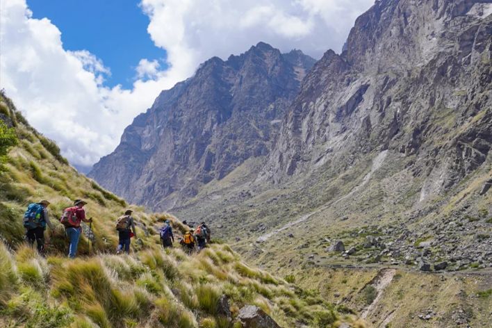
The trail gradually ascends, and you continue walking along the banks of the Alaknanda River, which stays with you for most of the route. Before long, you’ll witness the terrain opening into alpine meadows and rocky patches. On this stretch, you’ll walk on the terminal moraine of the Dhano Glacier, which is largely composed of loose rocks and glacial debris.
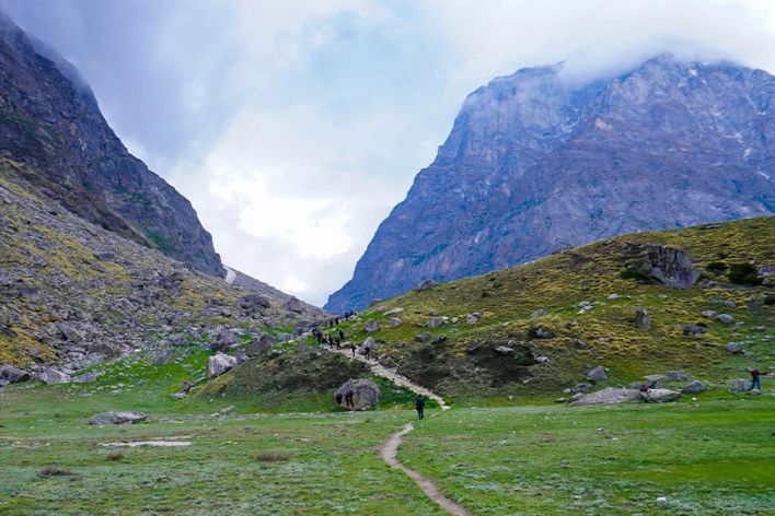
As you gain altitude, you’ll enter the Satopanth Valley, and the landscapes become more dramatic. On this stretch, you’ll enjoy wide open views of the valley in front of you. You can also witness seasonal, colorful alpine wildflowers with snow-laden peaks gleaming in the distance. Just as you are soaking in the natural beauty of this place, the view of the Bhagirathi peaks begins to open up in front of you.
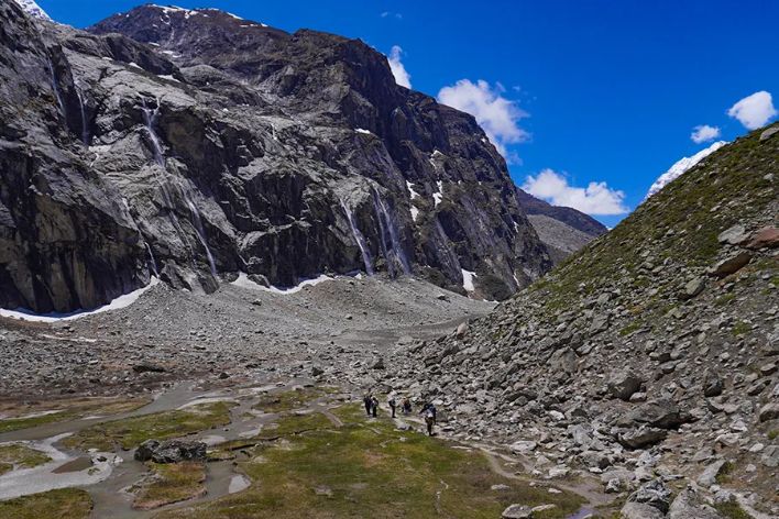
Trekking for about 5 km, you will reach another spectacular place called Shastradhara Falls. This striking waterfall is composed of hundreds of tiny waterfalls cascading down a rock face. The vibe of this place feels almost surreal and spiritual. From here, you also get your first good views of Mount Neelkanth on the left.
Chakrateertha Campsite is about a 30 to 40-minute walk from Sahastradhara. The trail continues through an open terrain, having a gradual ascent with panoramic Himalayan peaks looming on the horizon. Finally, you arrive at Chakrateertha (13,600 ft), a beautiful high-altitude meadow surrounded by towering peaks.
The campsite lies on a flat patch of a clearing. This is where your tents will be pitched for the night. Make sure you have enough warm layers on and cover your head properly. The temperature here during the daytime is 5°C to 10°C, and at night it can stoop down to 0°C to -5°C. It is also important to check signs of altitude sickness at this altitude. If you are showing signs like headache, nausea, loss of appetite, fatigue, or dizziness, then you should report to the trek leader immediately. Tonight, you will camp amidst greenery and towering peaks.
Day 5 – Chakrateertha to Satopanth Tal and Back
Altitude (Satopanth Lake): 4,360 m/ 14,500 ft.
Total Trek Distance: 10 km (5 km on each side).
Trek Duration: 8 hrs.
Gradient: Moderate to challenging (high altitude + moraine walking)


Today, the stretch from Chakrateertha to Satopanth Lake is one of the most thrilling and spiritually fulfilling parts of this trek. Since you have to come back today itself, the trek will start early after breakfast.
As the one-way distance (5km) is relatively shorter, it feels a bit physically demanding due to altitude, thinner air, and rugged terrain. The total distance is approximately 10 km, which takes about 8 hrs to complete.
In the beginning of the trek, the trail behaves gently, with a gradual ascent through a wide, open valley. The terrain, on the other hand, is rocky for the most part, with sparsely grown patches of grass. As the climb increases steadily, the landscape transitions into glacial moraine, which is basically composed of loose rocks, boulders, and debris left behind by glaciers. In this section, particularly, you’ll need careful footing and a steady pace.
As you further gain altitude, the visuals turn more exciting and dramatic. You’ll witness the Himalayan giants like Chaukhamba dominating the skyline, while Neelkanth Peak is right behind you, seen from certain angles. This valley feels vast, raw, and almost surreal.
The final climb to the lake is a ridge walk. Once you are at the top of the ridge, the landscape suddenly opens up. Finally, you are greeted by the serene, triangle-shaped Satopanth Tal, which sits at about 14,400 feet.
This high-altitude, beautiful alpine lake is surrounded by rocky terrain with towering peaks in the backdrop. Mythologically, the three sides of this triangular lake are linked to the Hindu Trinity (Brahma, Vishnu, and Shiva). The water is crystal clear and often reflects the surrounding peaks.
From this spot, on a clear day, you can see three out of the seven steps of the Swargarohini Glacier. It is believed that the Pandavas followed these steps to ascend into heaven. Spend some moments of solitude by the lake, enjoy the beauty and serenity of this place, and take pictures before you make your way back to the Chakrateertaha Campsite. It takes about 2 to 3 hrs to descend to the campsite from the lake.
Day 6 – Chakrateertha To Lakshmi Van
Altitude (Lakshmi Van): 3,600 m / 12,000 ft.
Trek Distance: 7 km.
Trek Duration: 3 – 4 hrs.
Gradient: Moderate (easier than ascent, but tricky in parts due to loose terrain)
Night Stay: In tents (twin-sharing)


On day 6, you’ll retrace your steps to the previous campsite, Lakshmi Van. The route is essentially a descent along the same trail you used while ascending. The high-altitude trekking routes, however, sometimes feel different as you have to walk downhill.
The trek starts after breakfast, and you descend gradually through a wide alpine valley. The morning views are especially breathtaking, with peaks like Chaukhamba towering on the horizon and Neelkanth occasionally visible.
Soon, you re-enter the glacial moraine zone, which can be more challenging while descending. You need to be extra careful to tread along these loose rocks and boulders. On this rugged terrain, it’s easy to slip if you rush, so controlled steps are important. This is where trekking poles will help you a great deal.
Once again, on the midway, you’ll pass through beautiful Sahastradhara Falls. It’s a great rest spot, where the sound of flowing water and greenery will refresh your mind. As you lose altitude, you witness alpine vegetation and start walking on stable trails. The air also feels slightly thicker and easier to breathe.
Finally, you reach the Lakshmi Van campsite again, which is a greener spot, dotted with shrubs and small trees. The transitioning scenery – from high-altitude rocky terrain into a green zone – is truly rewarding. Lunch will be served, and then you can take a rest.
Day 7 – Lakshmi Van to Mana Village and Drive to Pipalkoti
Altitude (Pipalkoti): 1,350 m / 4,400 ft
Trek Distance: 7-8 km; Duration: 3-4 hrs.
Drive Distance: approximately 80 km; Duration: 3-4hrs.
Stay: Guest House


The journey from Lakshmi Van to Mana Village marks the final leg of the Satopanth Lake trek. It’s a satisfying descent from high-altitude wilderness back to civilization. The trek distance is 7 to 8 km, which takes 3-4 hours to complete.
Descending along the same trail, you’ll initially pass through rocky terrain, but it gradually becomes easier. You’ll continue walking alongside the upper reaches of the Alaknanda River, guiding yourself through a widening valley. The constant sound of flowing water accompanies you.
After a few hours, you reach the point from where the stunning Vasudhara Falls is seen across the river. Here, you can take a rest and click some memorable pictures. From here, the trail becomes more defined and easier to walk. The last section is a well-marked trail with a gradual descent until Mana Village.
From Mana to Pipalkoti, the drive is approximately 80 km, which takes 4 – 5 hours. The drive takes you along the scenic mountain roads of Uttarakhand. You follow the Alakhnanda River downstream and pass hill stations like Joshimath. The road is winding but offers beautiful views of valleys and forests.
Finally, you’ll reach Peepalkoti before evening, and the stay will be at a guesthouse.
Day 8 – Drive from Pipalkoti to Rishikesh
Altitude (Rishikesh): 1,120 feet.
Drive: 220 km approx.; Duration: 9 to 10 hrs.
The ride will commence at 6 am, reaching the destination at around 7:30 pm.
Breakfast and lunch will be on the way at a roadside inn, exclusive of charges.

The beautiful time in the mountains ends today, as you will be driven back to Rishikesh. Wake up early and have a delicious breakfast, after which we will start our drive towards Rishikesh.
The drive will be along the same scenic routes where you can reminisce about your journey. It will take approximately 9 to 10 hours to reach Rishikesh. You can expect to reach Rishikesh by 7:30 PM.
Trek Location
Gallery Of Our Tours
Share This:
Trek Detail
Have Any Question?
With a strong focus on safety, sustainability, and cultural immersion, we help trekkers explore the true spirit and beauty of the Himalayas.
Spirit of Himalayas is a trekking company dedicated to offering authentic and well-curated Himalayan trekking experiences.
Quick Links
Useful Links
Newsletter
We help trekkers explore the true spirit and beauty of the Himalayas.
Payment:
We are proudly partnered with Turista Amigo to offer seamless travel experiences.
Copyright © 2025. All Right Reserved.